Core Facts about LiDAR You Should Know
Table of contents
Let’s Start from the Essentials: What Is the Practical Use of LiDAR?
What about creating a marketplace providing virtual home interiors or furniture catalogs without involving the designer’s effort at all?
Leveraging the power of Augmented Reality and mixed reality glasses for 3D gaming? Again, there’ll be no need to spend much time on tedious design processes.
Preparing detailed apartment plans to convey the atmosphere of the place and give 3D models ready to be stored, exported, or shared with interior architecture specialists for further real-time demonstration of their design concepts?
Today, all these use cases are becoming less than simple with the advanced LiDAR sensors incorporated in mobile phone cameras. Extra simplicity is achieved through engaging the Emerline's R&D team — we are diving deeply into the technology, exploring its hidden and explicit potential, and creating the solutions that make a difference in the AR world.
As a matter of practice, Emerline implements the LiDAR scanning for the creation of 3D layouts. The technology lets getting the scanned 3D rooms in full color (neural networks involved), identifying separate 3D objects, and making object classifications for working with each separately, if needed.
Emerline shows how LiDAR contributes to the quick 3D scanning.
New AR dimensions, more opportunities for the gaming industry, advanced virtual marketplaces, 3D houses and apartments, and the next-gen 3D models powered by the mixed reality — this overall ‘future-is-now-concept’ sounds promising. So what makes LiDAR a new wave in 3D scanning?
After highlighting our LiDAR practical experience, we are ready to shed light on the tech per se.
What Is LiDAR?
How Old Is It?
In fact, the technology is not that new — the first LiDAR, or Light Detection and Ranging, prototype appeared in 1961 and was created by Hughes Aircraft Company for military use. Then there was a US space program where the LiDAR technology was involved in moon surface mapping. Today, the LiDAR application fields are not limited to space only, covering also archeology, geography, forestry, laser guidance, autonomous machines, etc.
How does LiDAR Work?
In a nutshell, LiDAR is a remote sensing method aimed to measure distances “by illuminating the target with laser light and measuring the reflection with a sensor. Differences in laser return times and wavelengths can then be used to make digital 3D representations of the target.”
Among the key components of LiDAR are the scanner and laser. They all contribute to accurate data collection as well as the optics and photodetectors.
Depending on the functionality, LiDAR solutions are divided into:
Airborne (a dynamic multi-sensor system that uses a navigation unit (GNSS, IMU) to measure the time of flight of a signal from a source to its return to a sensor; it is commonly installed on a helicopter/drone to collect necessary data);
Terrestrial (another term is topographic LiDAR; a ground-based option of the airborne LiDAR that is installed on moving vehicles and used for terrain or landscape mapping. It quickly identifies various roadway assets and infrastructure. The operating principle is similar to airborne — laser signals measure the distances based on the delays of the returning laser pulses).
What Are the Pros and Cons of LiDAR?
Do not confuse LiDAR with RADAR — although sounding similar, they are different concepts with various working mechanisms.
Let’s take a closer look at the functioning algorithm of each.
LiDAR emits laser signals that reach an object, reflect, and return to the receiver. The core difference between LiDAR and RADAR is that the latter uses radio waves instead of the sound, while following the similar purpose of object detection and the same working principle.
Among some standalone benefits of the LiDAR technology is the opportunity to be integrated with the other data sources. It automates and simplifies complex data analysis and processing. While facing definite environmental restrictions, LiDAR sensors are not limited by geometrical distortions, which makes the LiDAR tech stand out among the other forms of data collection.
As for the effective application fields, RADAR is definitely preferable in case the distance is prior to the object look. When we need to identify the object type, LiDAR with its light-based principle is more effective.
What Are the Top Uses of LiDAR?
It’s time to explore the areas that gain the most benefits from Light Detection and Ranging. Where is investigating environments and making their 3D models becoming of vital importance? Here are the most popular industries that actively engage the LiDAR’s power in completing their tasks.
Agriculture
That’s one of the first associations when it comes to surfaces and grounds. LiDAR works nicely for analyzing the soil quality, crop conditions, and field state (on a regular basis and throughout different growth stages) to achieve an impressive harvest. LiDAR is also good for making precise crop categorization and identifying the appropriate areas for planting.
Autonomous vehicles
The idea of self-driving cars has been put into practice thanks to the LiDAR sensors. That is how these vehicle types ‘see’ the surroundings and pedestrians, obstacles, or other cars. From precise navigation and obstacle detection to adaptive cruise control — these are the LiDAR’s responsibility areas.
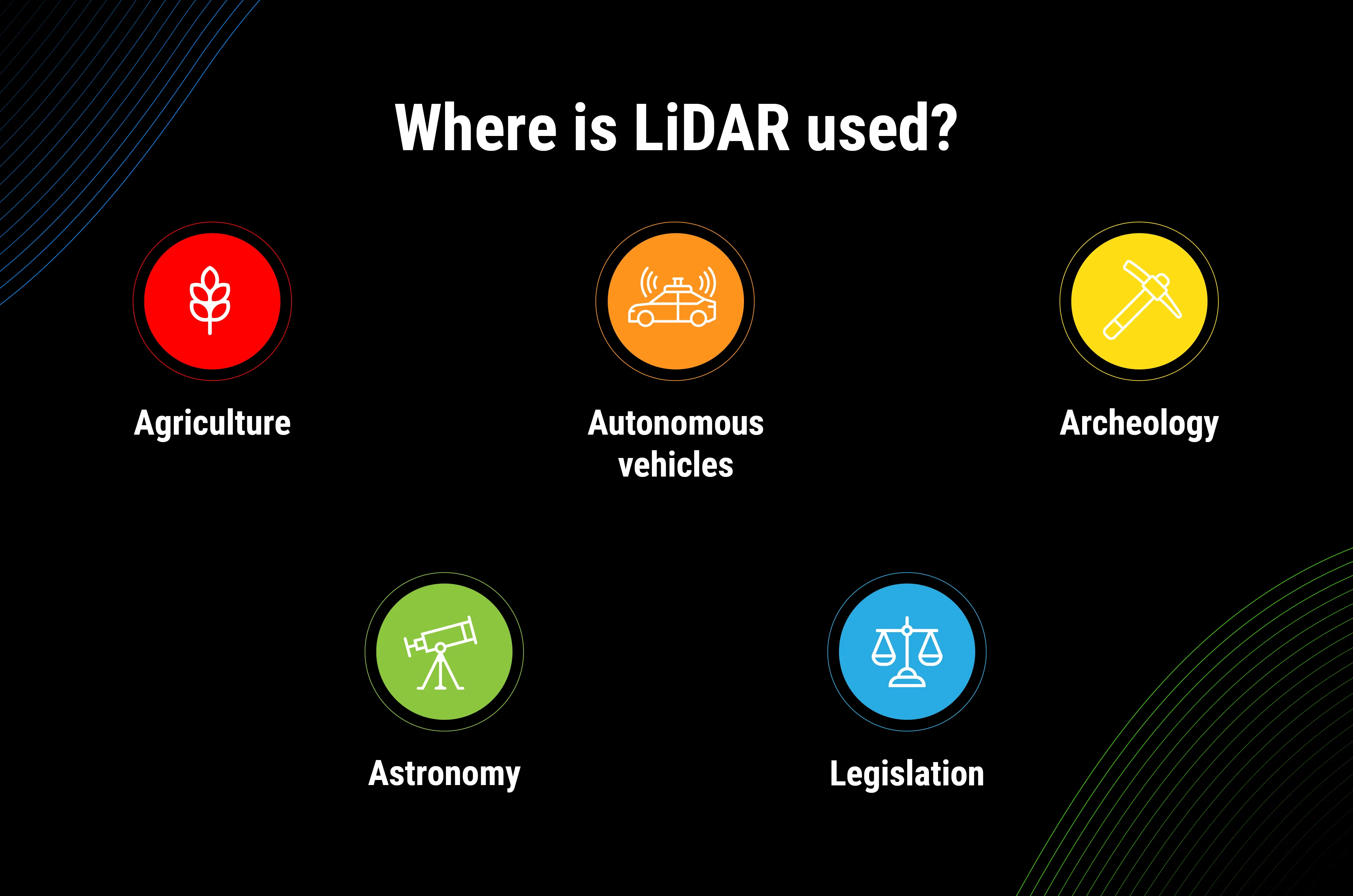
Archeology
LiDAR has proven its worth for microtopography-related tasks — archeologists take a closer look at the surface, define topographic variability, and examine vegetation structures.
Astronomy
NASA mentions LiDAR as the central tech for providing safe vehicle landing onto the lunar surface. The usage of the LiDAR technology for developing topographic maps was quite common even at the end of the 20th century. As mentioned above, it’s already a history.
Legislation
To streamline law reinforcement activities, LiDAR systems are aimed at capturing crime scenes, visualizing fingerprints in 3D, and conducting precise forensic examinations. Laser pulses also measure the speed, so that the number of drivers going over the speed limit decreases.
While focusing on the key industries using LiDAR, we can move on with more and more examples of LiDAR uses. The technology has taken roots in the fields of biology, mining, transportation, media and entertainment, etc.
Well, we’ve come to the heart of the matter. What does LiDAR mean for AR? Why does Apple pin hopes on it? Do LiDAR scanners have all chances to make breakthroughs in the digital world?
Apple and LiDAR
The LiDAR scanner conquers Apple products — being implemented in the new iPad Pro, it’s going to enrich the Phone’s functional capabilities as well. To be substantive, LiDAR presents a new era of AR experiences, while giving far more detailed understanding of the scenes. Among the ARKit’s improvements are more accurate motion captures and the overall better performance.
Calculating heights or areas becomes as simple as ABC, and 3D gaming acquires incredibly true-to-life objects.
Will the LiDAR scanner lay claim to becoming a game-changer for mobile? For now, it’s definitely an innovative way to create cutting-edge AR applications. Emerline keeps pace with the spread of this latest tech and delves into examining its practical usage. If you are curious about the LiDAR-powered iOS applications or want to know more about LiDAR for mobile today, you are free to reach out to our experts. We are ready to provide more info and show you how it works.
Published on Jun 26, 2020